| Sealevel Systems' High Speed 4111 Card Makes Communications a Success in Measurement-Related NASA Shuttle Laser Altimeter I and Shuttle Laser Altimeter II Projects.
In today's age of onboard global positioning systems in the family car, it's easy to assume that we have the world pretty well mapped out. That's not always the case, however, as many of the measurements we rely on - especially those related to altitude - are actually relative measurements. For example, we may know the height of a mountain or depth of a valley as relative to the measurement of another nearby land formation, which is relative to yet another landmark, and so on and so on and so on. NASA's Shuttle Laser Altimeter I and Shuttle Laser Altimeter II projects have opened a new window into obtaining accurate, direct measurements, with the help of an RS-422 card from Sealevel Systems.
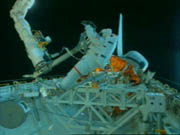
The Geodynamics Branch of the Goddard Space Flight Center's Laboratory for Terrestrial Physics had been researching direct measurement advances and techniques for more than a decade when engineers decided to adapt an airborne laser altimeter for use on the Space Shuttle. 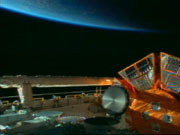 The Shuttle provided a vista which could never be attained in an airplane providing that the measurement laser and its corresponding computers could be operated remotely. At that point, the Goddard Space Flight Center called on Sealevel Systems, which has continuously supplied equipment to shuttle missions. The Shuttle provided a vista which could never be attained in an airplane providing that the measurement laser and its corresponding computers could be operated remotely. At that point, the Goddard Space Flight Center called on Sealevel Systems, which has continuously supplied equipment to shuttle missions.
The project required an RS-422 card with dual channels, and a Sealevel high speed Sync/Async card fit the bill. The card was worked into both the laser setup on the Shuttle and into the control modules on the ground to facilitate communications on a microwave link that engineers characterize as being "the same as having them cabled together." The communications function was made even more important due to the fact that the Shuttle's reentry and landing meant that anything can happen to the hard drives and information situated on the Shuttle. For this reason, as much data as possible must be relayed to and stored on the ground. Plus, conditions in orbit meant that the high-speed data channel was only open 20 minutes a day.
Sealevel's Sync/Async card facilitated data transmission of the Shuttle Laser Altimeter's findings, including measurements of the heights of ground surfaces and vegetation canopies gathered from 3 million laser shots. Meanwhile, the whole system is controlled remotely from the ground station through the use of signals (control codes) transmitted by the high speed 4111 card.
"The Sealevel card was chosen because it fit the specifications we needed, and also because we trusted its reliability and knew that Sealevel had been in business forever," says David Rabine, Aerospace Engineer, Goddard Space Flight Center. "It worked so well that we plan to use it in several more projects and in devices that are going to be used in two more upcoming Shuttle flights."
In fact, the Sealevel 4111 card will perform much the same function in the Earth System Science Pathfinder Project's first mission, the Vegetation Canopy Lidar mission, currently in the works at the Goddard Space Flight Center. The mission is, in a sense, an expansion of the Shuttle Laser Altimeter project, with goals including compiling a global reference data set of topographic spot heights and transects.
Sealevel Systems, founded in 1986, is a provider of communications and I/O solutions for multiple platforms including PCI Bus, ISA Bus, PC Card (PCMCIA) and PC/104. The product line includes multi-port RS-232 and RS-422/485 cards, high-speed sync/async adapters, digital/relay I/O boards, and Solid State Disk emulation. In addition to its products, the company provides related software, technical support and customer service, and offers customization capabilities to meet customer's unique application needs.
For more information, please contact Sealevel Systems by phone at (864) 843-4343, or by e-mail at sales@sealevel.com.
Simpler Solutions Fact Sheet:
Shuttle Laser Altimeter Project
- Product: Sealevel Systems 4111 RS-422 card
- Client NASA Goddard Space Flight Center, Laboratory of Terrestrial Physics
- Application Facilitate Earth-to-space communications for the Shuttle Laser Altimeter project
- Dates Shuttle Laser Altimeter I: Mission STS-72, January 11-20, 1996; Shuttle Laser Altimeter II: Mission STS-85, August 7-18, 1997
- Key Results Direct measurement of land topography and vegetation, primarily in the Southern Hemisphere.
|